How to read a sectional chart for the Part 107 test
Chart questions are the most-missed part of the test. This six-step method works on any sectional chart question.
What a sectional chart is
A sectional chart is the FAA’s VFR map for pilots. It shows airspace, airports, terrain, obstacles, and special areas at a scale of 1:500,000, about 6.9 NM per inch. Sectionals are updated every 56 days and are free from the FAA in digital form.
At the testing center you’ll get the Airman Knowledge Testing Supplement (FAA-CT-8080-2H) for figure questions. You may also see chart images taken from current sectionals inside the question itself. The skill is the same for both.
Exam tip Chart figures in the test are not to scale. Never measure distance with your finger. Use the numbers and the symbols.
The LOCATE method
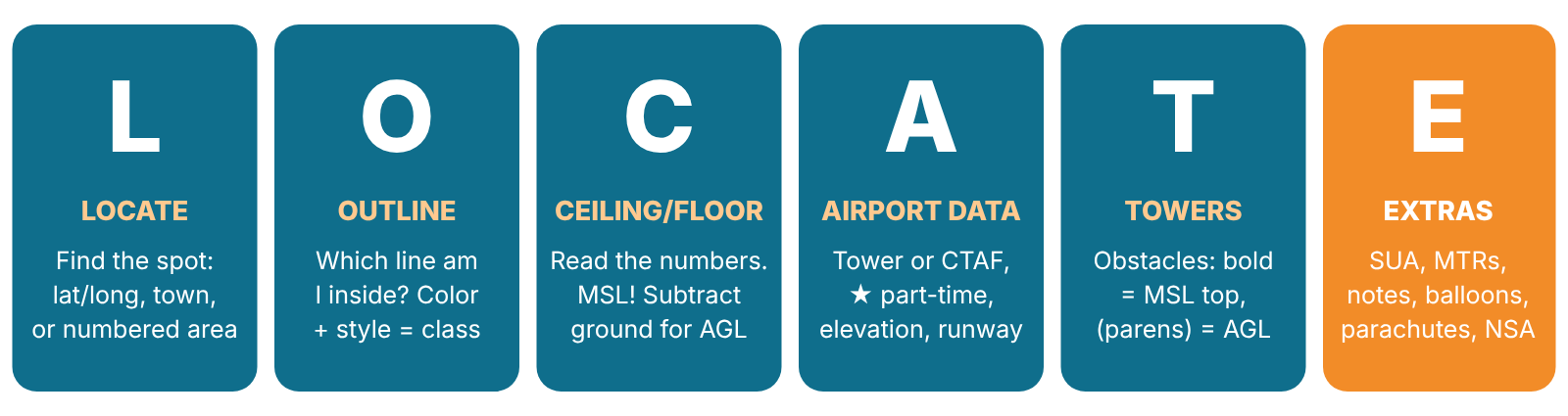
- L – Locate the spot the question asks about: a numbered area, a town, an airport, or a latitude and longitude.
- O – Outline. Which line surrounds the spot? Its color and style tell you the airspace class (8.3).
- C – Ceiling and floor. Read the altitude numbers for that airspace. Remember they’re MSL. Convert to AGL if the question asks (8.4).
- A – Airport data. If the question involves an airport, read its data block: tower or CTAF frequency, elevation, lighting, runway length (8.5).
- T – Towers and obstacles. Find obstacles near the spot. Bold number = top in MSL. Number in parentheses = height AGL (8.6).
- E – Extras. Check for special use airspace, MTRs, parachute areas, balloons, NSAs, stadiums, and chart notes (“See NOTAMs…”) (8.7).
Common trap Most wrong answers come from skipping a step. Students often read the airspace correctly (step O) but forget the altitude is MSL (step C), or miss a part-time tower star (step A). Run all six steps every time.
Outline: identify the airspace by its line
| What you see | Airspace | Authorization? |
|---|---|---|
| Solid blue lines, numbers like 100/30 | Class B | Yes |
| Solid magenta lines, numbers like 40/SFC or 40/12 | Class C | Yes |
| Dashed blue line, number in a dashed box like [25] or [-20] | Class D | Yes |
| Dashed magenta line | Class E surface area | Yes |
| Magenta shaded band (vignette), fuzzy side inward | Class E from 700 ft AGL (Class G below) | No |
| Blue shaded band (vignette) | Class E, usually from 1,200 ft AGL, on the soft side | No |
| No line at all | Usually Class G to 700 or 1,200 ft AGL | No |
| Blue hatched border, P-, R-, or W- label | Prohibited, restricted, or warning area | Prohibited: never. Restricted: permission |
| Magenta hatched border, MOA name or A- label | MOA or alert area | Caution |
Ceilings and floors: always MSL
Class B and C show ceiling over floor in hundreds of feet MSL: - 40/SFC → from the surface to 4,000 ft MSL - 40/12 → from 1,200 ft MSL to 4,000 ft MSL - T as a ceiling → up to, but not including, the floor of the Class B above it
Class D shows only its ceiling, in a dashed box, in hundreds of feet MSL: - [25] → surface to 2,500 ft MSL - [-20] → surface up to but not including 2,000 ft MSL (another airspace begins at 2,000)
Converting MSL to AGL. Subtract the ground elevation:
AGL = MSL − ground elevation A Class C shelf floor of 1,200 MSL over ground at 400 ft begins 800 ft AGL above you.
Number to know: 40/12 Read top to bottom: ceiling 4,000 MSL, floor 1,200 MSL. Add two zeros to each number.
Airport data blocks
Airport symbol color: blue = airport with a control tower. Magenta = no tower (non-towered).
A typical data block for a towered airport:
| Item | Example | Meaning |
|---|---|---|
| Name and identifier | ELIZABETH CITY CGAS/RGNL (ECG) | Airport name and code |
| CT + frequency | CT – 120.5 ★ | Control tower frequency. ★ = part-time tower |
| Ⓒ | 120.5 Ⓒ or 122.9 Ⓒ | CTAF, the Common Traffic Advisory Frequency used when no tower is operating |
| Weather | ATIS, ASOS, AWOS + frequency | Recorded or automated weather |
| Elevation | 11 | Field elevation in feet MSL |
| Lighting | L or *L | L = runway lights. *L = lighting limitations; check the Chart Supplement |
| Runway length | 72 | Longest runway in hundreds of feet, here 7,200 ft |
| UNICOM | 122.95 | Airport advisory frequency |
| RP + runways | RP 1, 10, 19 | Right-hand traffic pattern for those runways |
Exam tip A question asking which frequency to monitor at a non-towered airport, or a towered one after hours, wants the CTAF, the number with the Ⓒ.
Towers and obstacles
- Bold number next to an obstacle symbol = top of the obstacle in feet MSL.
- Number in parentheses = height above ground (AGL).
- A taller symbol marks obstacles 1,000 ft AGL or higher.
- UC = under construction or reported but not verified.
- Guy wires can extend well beyond a tower. Keep your distance.
Maximum Elevation Figures (MEFs) are the big blue numbers in each quadrant. They show the highest terrain or obstacle in that box, rounded up: 1² = 1,200 ft MSL, 0⁴ = 400 ft MSL.
Common trap Obstacle numbers are not airspace numbers. A tower marked 1049 (1041) is 1,049 ft MSL at the top and 1,041 ft tall. It tells you nothing about the airspace class.
Extras: what else is on the chart
- Special use airspace labels (P-, R-, W-, A-, MOA). Details are in the table on the chart border.
- Military Training Routes (gray lines, IR/VR + number).
- Parachute symbols, glider, and ultralight areas.
- Caution notes in boxes, such as unmarked balloons on cables.
- “See NOTAMs/Directory for Class D/E (sfc) eff hrs”: the airspace is part-time. Check the Chart Supplement for hours.
- “CTC … APP WITHIN 20 NM”: an instruction for manned aircraft to contact approach control. It’s not an airspace boundary.
- National Security Areas (broken magenta line). Voluntary avoidance, and they can become prohibited by NOTAM.
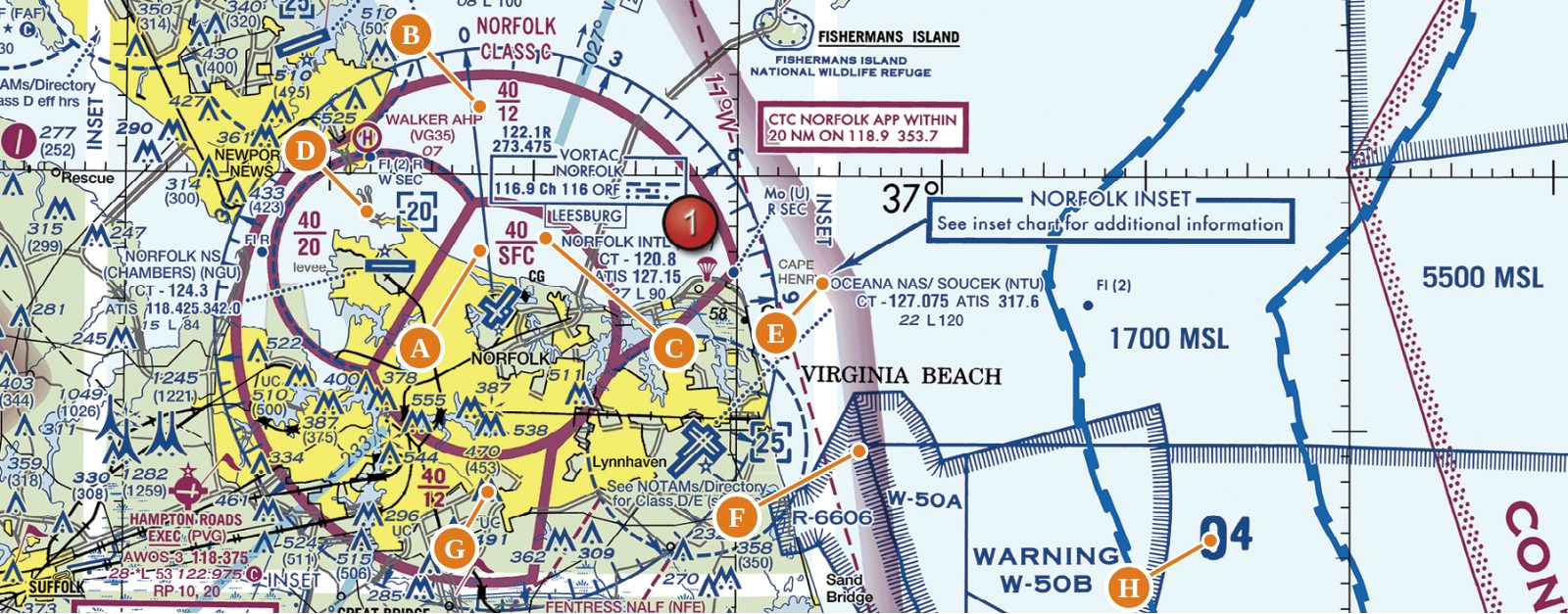
Worked example 1: Norfolk, Virginia
| Letter | What you see | What it means |
|---|---|---|
| A | 40 / SFC inside the solid magenta inner ring | Class C core: surface to 4,000 ft MSL. Any drone flight here needs ATC authorization. |
| B | 40 / 12 in the outer ring | Class C shelf: 1,200 to 4,000 ft MSL. Below 1,200 MSL you are not in Class C. Check what lies underneath. |
| C | NORFOLK INTL, CT – 120.8, ATIS 127.15, 27 L 90 | Blue symbol: towered. Tower 120.8 (no ★, so full-time). Weather on ATIS 127.15. Elevation 27 ft MSL, lighted, longest runway 9,000 ft. |
| D | Dashed box [-20] | Class D (Chambers NAS) from the surface up to but not including 2,000 ft MSL, where the Class C above takes over. |
| E | OCEANA NAS / SOUCEK (NTU), CT – 127.075 | A second towered airport, a naval air station. Expect high-performance military traffic. |
| F | Blue hatched border, R-6606, W-50A/B | A restricted area and warning areas offshore. No entry into R-6606 without permission from the controlling agency. |
| G | 470 (453) | Obstacle: top at 470 ft MSL, 453 ft AGL. |
| H | Large 0⁴ | MEF: highest terrain or obstacle in this quadrant is 400 ft MSL. |
Exam tip Over the town of Norfolk, under 40/SFC, any altitude is Class C, so authorization is required. Out under 40/12, a drone at 300 ft AGL over sea-level ground is below the Class C floor.
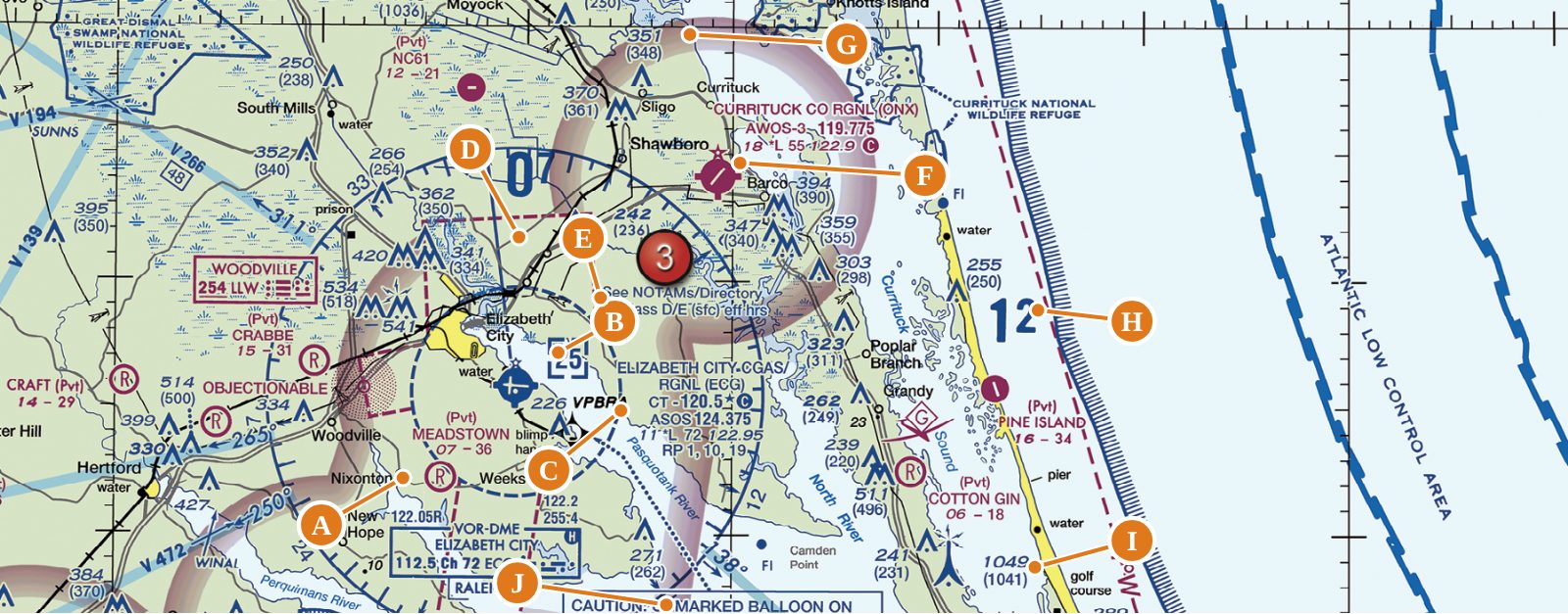
Worked example 2: Elizabeth City, North Carolina
| Letter | What you see | What it means |
|---|---|---|
| A | Dashed blue circle around the airport | Class D airspace. Authorization required. |
| B | Dashed box [25] | Class D ceiling: surface to 2,500 ft MSL. |
| C | CT – 120.5 ★ Ⓒ, ASOS 124.375, 11 *L 72 122.95, RP 1, 10, 19 | Part-time tower (★) on 120.5, which is also the CTAF (Ⓒ) when the tower is closed. Automated weather on 124.375. Elevation 11 ft, lighting limitations (*L), longest runway 7,200 ft, UNICOM 122.95, right traffic for runways 1, 10, 19. |
| D | Dashed magenta line | Class E surface area extension. Authorization required here too. |
| E | “See NOTAMs/Directory for Class D/E (sfc) eff hrs” | The Class D and E surface areas are part-time. Check the Chart Supplement for hours. |
| F | CURRITUCK CO RGNL (ONX), magenta, AWOS-3 119.775, 122.9 Ⓒ | Non-towered airport. Monitor the CTAF 122.9. Weather on AWOS-3. |
| G | Magenta shaded band around Currituck | Class E begins at 700 ft AGL. Below it is Class G, with no authorization needed. |
| H | Large 1² | MEF 1,200 ft MSL for this quadrant. |
| I | 1049 (1041) with the tall symbol | Obstacle 1,000+ ft AGL: top 1,049 ft MSL, 1,041 ft tall. |
| J | “CAUTION: UNMARKED BALLOON ON CABLE TO 3008 MSL” | A tethered balloon with a cable. Avoid flight beneath or near unmanned balloons (ACS UA.II.B.K4b). |
Start a free practice test