Decoding METARs and TAFs for Part 107
Every group in a METAR and TAF, decoded with real examples, plus what each one means for a drone flight.
Decoding a METAR
A METAR is an observation of current surface weather in a standard format. A SPECI is a special report issued between routine METARs when conditions change significantly.
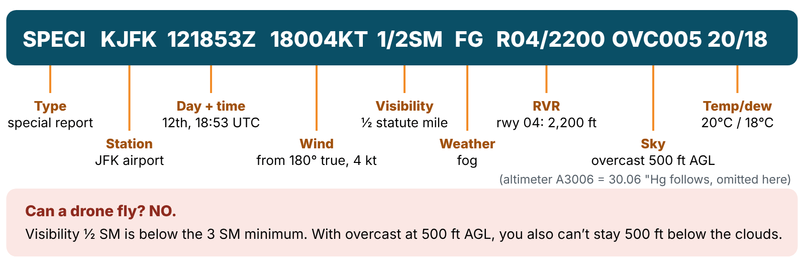
| Group | Example | Meaning |
|---|---|---|
| Type | METAR / SPECI | Routine / special report |
| Station | KJFK | K + 3-letter identifier in the lower 48 states. PA = Alaska, PH = Hawaii |
| Date/time | 121853Z | Day 12, 18:53 UTC |
| Modifier | AUTO / COR | Automated report / corrected report |
| Wind | 18004KT, 11012G18KT, VRB03KT | Direction from, in degrees true, then speed in knots. G = gusts. VRB = variable |
| Visibility | 1/2SM, 15SM | Prevailing visibility in statute miles |
| RVR | R04/2200FT | Runway visual range: runway 04, 2,200 ft |
| Weather | –RA, +TSRA, BR, FG, HZ | – light, no sign moderate, + heavy. TS thunderstorm, RA rain, SN snow, BR mist, FG fog, HZ haze, VC in the vicinity (5–10 miles) |
| Sky | SCT007 OVC012CB | Amount + height in hundreds of feet AGL + type (CB cumulonimbus, TCU towering cumulus) |
| Temp/dew point | 20/18, M05/M08 | °C. M = minus |
| Altimeter | A3006 | 30.06 inches of mercury |
| Remarks | RMK RAB35 | Rain began at :35 past the hour. PRESFR = pressure falling rapidly |
Sky cover contractions:
| Code | Meaning | Sky covered |
|---|---|---|
| SKC / CLR | Clear | 0/8 |
| FEW | Few | 1/8 – 2/8 |
| SCT | Scattered | 3/8 – 4/8 |
| BKN | Broken | 5/8 – 7/8 |
| OVC | Overcast | 8/8 |
| VV | Vertical visibility into an obscuration | — |
Ceiling = the lowest broken (BKN) or overcast (OVC) layer, or the vertical visibility (VV) into an obscuration. FEW and SCT are not ceilings.
Number to know: BKN / OVC Only BKN, OVC, or VV make a ceiling. “SCT007” is not a ceiling, but those clouds still count for your 500 ft below clearance.
Practice: the testing supplement’s Figure 12
| METAR | Decoded | Part 107 OK? |
|---|---|---|
| KINK 121845Z 11012G18KT 15SM SKC 25/17 A3000 | Wind 110° at 12 kt, gusts 18. 15 SM. Clear | Yes, but expect gusts |
| KBOI 121854Z 13004KT 30SM SCT150 17/6 A3015 | Wind 130° at 4. 30 SM. Scattered at 15,000 | Yes |
| KLAX 121852Z 25004KT 6SM BR SCT007 SCT250 16/15 A2991 | 6 SM in mist. Scattered at 700 ft (not a ceiling). Temp/dew point 1° apart | Yes, up to 200 ft AGL (stay 500 ft below the clouds at 700) |
| SPECI KMDW 121856Z 32005KT 1 1/2SM RA OVC007 17/16 A2980 RMK RAB35 | 1½ SM in rain. Overcast 700 (ceiling). Rain began at :35 | No, visibility below 3 SM |
| SPECI KJFK 121853Z 18004KT 1/2SM FG R04/2200 OVC005 20/18 A3006 | ½ SM fog. RVR 2,200. Overcast 500 | No |
Decoding a TAF
A TAF (Terminal Aerodrome Forecast) covers a 5-statute-mile radius around an airport for 24 or 30 hours. TAFs are issued four times a day, at 0000Z, 0600Z, 1200Z, and 1800Z. They use the same codes as METARs, plus change groups:
| Group | Meaning |
|---|---|
| 0512/0618 | Valid from day 05 at 12Z to day 06 at 18Z |
| P6SM | Visibility greater than 6 statute miles |
| FM051600 | From day 05 at 1600Z: a rapid, lasting change |
| TEMPO 0513/0516 | Temporary fluctuations, each lasting less than an hour, between 13Z and 16Z |
| BECMG 0522/0524 | Becoming: a gradual change between 22Z and 24Z |
| PROB40 0600/0606 | 40% probability of the stated conditions between 00Z and 06Z |
| 00000KT | Calm wind |
| = | End of the forecast |
Worked example (Figure 15, KOKC):
KOKC 051130Z 0512/0618 14008KT 5SM BR BKN030 TEMPO 0513/0516 1 1/2SM BR FM051600 18010KT P6SM SKC BECMG 0522/0524 20013G20KT 4SM SHRA OVC020 PROB40 0600/0606 2SM TSRA OVC008CB BECMG 0606/0608 21015KT P6SM SCT040=
- Issued on the 5th at 1130Z, valid 5th 12Z to 6th 18Z.
- To start: wind 140° at 8 kt, 5 SM in mist, broken 3,000 ft.
- Temporarily between 13Z and 16Z: 1½ SM in mist. Below Part 107 minimums.
- From 1600Z: wind 180° at 10, more than 6 SM, clear.
- Becoming between 22Z and 24Z: wind 200° at 13 gusting 20, 4 SM in rain showers, overcast 2,000.
- 40% chance between 00Z and 06Z of 2 SM, thunderstorms with rain, overcast 800 ft with cumulonimbus.
- Becoming between 06Z and 08Z: wind 210° at 15, more than 6 SM, scattered at 4,000.
Exam tip FM = a sharp, lasting change. TEMPO = a short burst (under 1 hour each time). BECMG = a gradual change. PROB30/PROB40 = a 30% or 40% chance.
Start a free practice test